Inuvik to Ushuaia
Mountains and People: Perceptions of Northern Peru
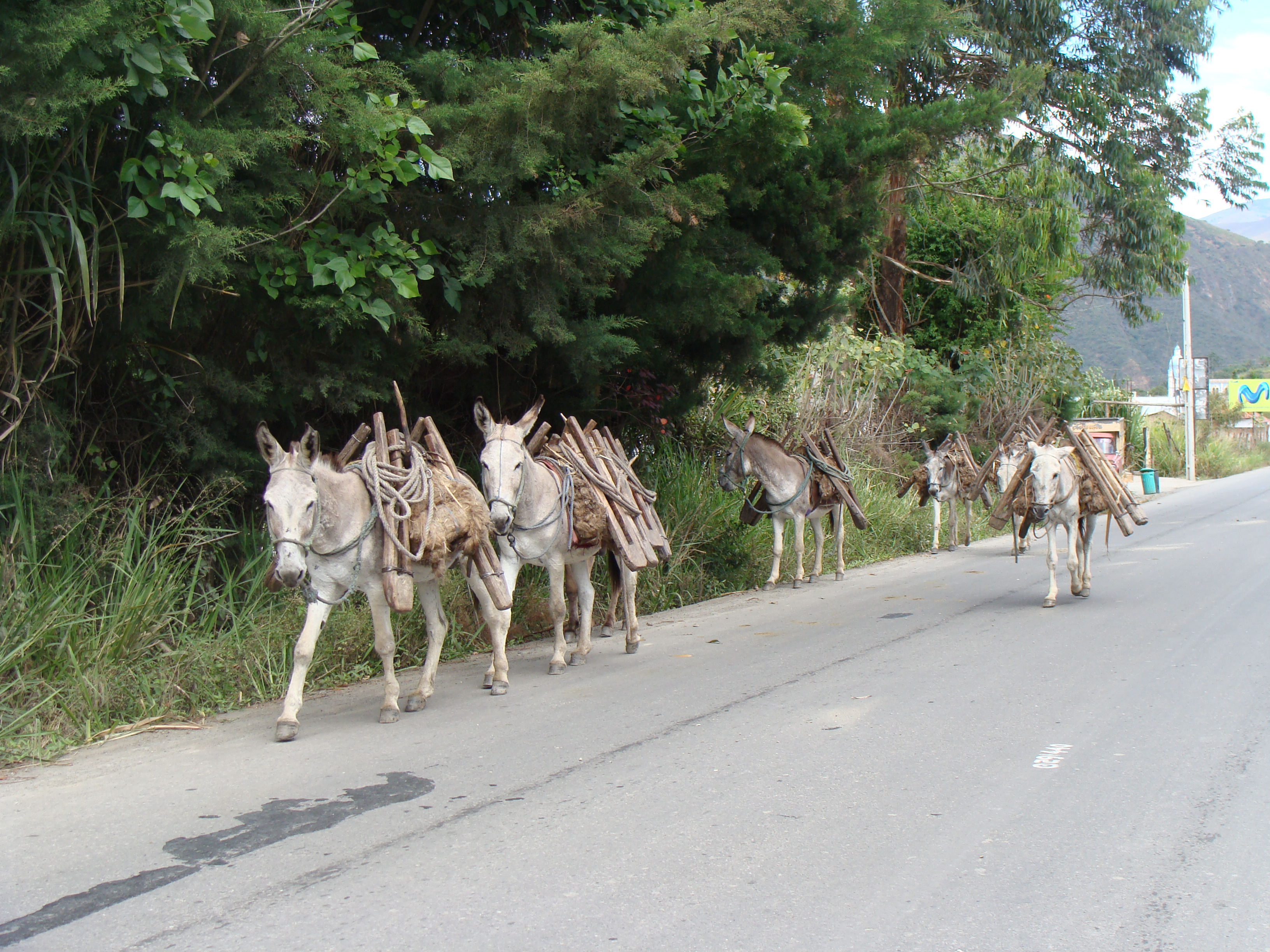
Peru has some of the biggest mountains and deepest valleys we have encountered so far. We find it very interesting to ride the high mountains of Peru because the sierras are inhabited by indigenous people who live in the traditional ways they have maintained for centuries. Not much has changed in hundreds of years. In some areas we have been riding through there is no electricity, no running water, no paved road, lots of sheep, cows, chickens, donkeys which carry cargoes of milk, wood, heavy loads of vegetables like potatoes, corn and cabbage. The people themselves carry huge loads on their backs. The women wear the same traditional clothes they have for ages including special hats which identify the area they come from. Around Cajamarca the women wear short skirts with ballooning petticoats, tall, wide-brimmed hand-woven hats made of fine strands of straw. They all have wraps and ponchos to either keep warm or carry a load. They're even shorter than me. From the distance they sometimes remind me of the profile of Halloween witch The women in Northern Peru can be seen herding donkeys loaded with metal containers of milk, babies on their backs and walking along a high mountain road while spinning wool on a stick, preparing the wool for knitting or weaving. The women always have busy hands. Always. Where we are right now the women knit afghans of multiple colors, ponchos, and sweaters. If they don't have a baby on their backs they're carrying a load of firewood, twigs, or huge bunches of herbs and greens. read more here... lee mas aquí... »
The Potato Truck Ride from Leymebamba to Celendín in Northern Peru
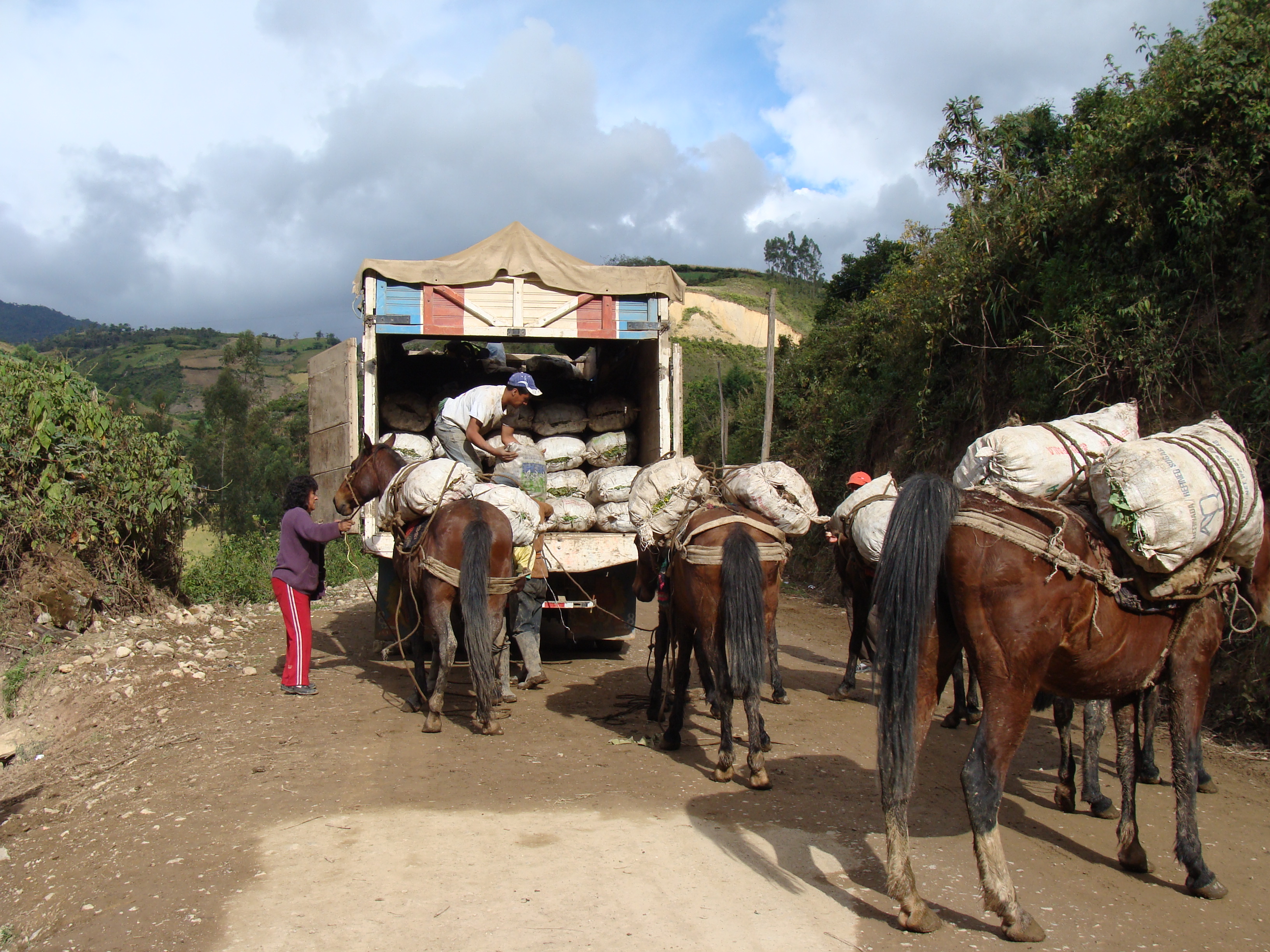
OK, I must confess we took a ride in a truck full of freshly-picked potatoes. The 100-mile ride took 10 hours through some very high mountains of northern Peru and down though hot valleys and back up to the heavens.
We have decided (or is it that I have decided?) that occasionally it does make sense to take alternative transportation through some areas which seem too difficult for biking with our load. The route we have taken through northern Peru has taken us through very beautiful, amazing landscapes. And amazing elevation climbs, descents and ascents. In one area from Leymebamba to Celendin, after reading another cyclist's blog through this area, I was intimidated and decided I would rather take a bus then climb up to 3600 meters (12,000 feet), descend to 900 meters (3000 feet) and then climb back up to 3100 meters on a dirt road, along cliffs that drop thousands of feet with only a slice of road carved on the face of the mountain. read more here... lee mas aquí... »
Bike Maintenance Log
Several of you bike touring people have asked us about bike maintenance and the problems we've had, so we decided to put together a log.
July 2006: Cassiar Highway. Broken spoke and wobbly wheel on Randy's drive side of rear wheel. We broke the Hyper-Cracker tool (that takes the cassette off) in a hailstorm trying to use it. Took us 300 miles to get to a place with a tool to take it off, but we made it.
September 2006: New tires in Victoria, BC.
October 2006: California: Spoke nipple broke through rim on Randy's rear wheel. Got a new wheel built, hoping for the best.
January 2007: New bottom bracket for Randy's bike. New drive train, cables, housing, tires (Continental TravelContact), touring handlebars, many other things before starting out. We also had to buy a replacement set of Old Man Mountain racks for Randy's bike because the 5000 miles of the trip so far had created big abrasions in the (aluminum) racks. Old Man Mountain gave us the new racks at cost.
February 2007: Randy's new rear wheel (from California) failed in Tucson. It was a fancy downhill rim, too. We'll never use another Mavic rim of any type for bike touring.
April 2007: Randy gave up on the fancy Brooks saddle (never did get comfortable) and got a new one, Terry touring saddle that seems to be OK.
May 2007: New chains and cassettes on Oaxaca, Mexico.
January 2008: New chains in Guatemala.
January 2008: Nancy's seatpost clamp failed in Honduras. read more here... lee mas aquí... »
Peru Route: July 13 to October 9, 2008
Here is our route in Peru.
Each day has elevation profile, map, and GPS information.
Other recommended information sources::
- We used the trip notes from 2bike.be,(at the bottom of the page) which are quite detailed and very useful. They include total elevation and what shops and hospedajes are found along the way.
- PDFs of daily route notes from Florian and Rebekkah are gems of information. These are rehashes of a set that has been carried by many cyclists.
- Also, Pius and Stefan of panamerica.ch have done a great job with more consolidated elevation profiles than we show here. Take a look at their Peru map page and study their route profiles in PDF format. They took our same route from Trujillo to Bolivia.
- Maps: We used the Rough Guide Map of Peru most of the time, and thought it was pretty decent. ITMB also has a map, and Lima2000 has a pretty decent map that you can get within the country.
- GPS: The free routeable GPS maps at perut.org have been recommended highly. Also, Guiacalles.com in Lima has a full GPS map for sale.
Skip to:
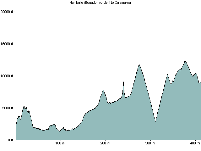
Ecuador border to Cajamarca
The route we took is difficult and opened only in 2000 or so, so most cycle tourists seem to go the Panamerican Highway from Loja, Ecuador to Trujillo, Peru. This is fairly fast, but they all hate it. On the contrary, we really loved the mountainous way we went, even though it's challenging.
From the border there is a gentle but long climb of 1300 meters and then a descent into San Ignacio. It's mostly downhill then to the valley of the Rio Marañon at just 400 meters of elevation. We took a turnoff and went through Bella Vista instead of staying on the main road through Jaen. This saved many kilometers and was a pretty pleasant (dirt) road cutoff. We took a small ferry across the river just beyond Bella Vista.
After returning to the highway and getting to Bagua Grande, we started the beautiful climb up the Rio Utcubamba to Pedro Ruiz. Because of road construction we had to take a combi from the intersection there to Chachapoyas. Then lovely dirt road to El Tingo (Kuelap) and Leymebamba. From Leymebamba to Celendín is a huge climb and drop to the Rio Marañon again; we did it in a potato truck. Then from Celendín to Cajamarca is one pass - there is pavement on the Cajamarca side. We took a bus from Cajamarca to Trujillo.
| Ride | date | miles/km | Elev ft/mt |
|---|---|---|---|
| Namballe, Peru to San Ignacio, Peru | 2008-07-13 | 28/45 | 4300/1327 |
| San Ignacio to Tamborada | 2008-07-16 | 45/73 | 1650/509 |
| Tamborada to Bagua Grande via Bella Vista | 2008-07-17 | 43/69 | 2034/628 |
| Bagua Grande to Pedro Ruiz and by combi to Chachapoyas | 2008-07-18 | 42/68 | 3600/1111 |
| Chachapoyas to El Tingo | 2008-07-19 | 23/37 | 518/160 |
| El Tingo to Kuélap by car | 2008-07-20 | 1/2 | 4000/1235 |
| El Tingo to Leymebamba via Revash | 2008-07-21 | 35/56 | 2332/720 |
| Leymebamba to Celendín by potato truck | 2008-07-22 | 89/144 | /0 |
| Celendín to Cruz Conga | 2008-07-23 | 21/34 | 2539/784 |
| Cruz Conga to Cajamarca, Peru | 2008-07-24 | 47/76 | 2122/655 |
Trujillo to Huancayo
The route from Trujillo to Huancayo is pretty standard (and fairly difficult) for bike tourists. You ride a little ways south on the Pan American Highway to 15km south of Chao, then turn into a private road, climb up to the Cañon del Pato, up to Huaraz, then either through the national park or around the paved road and over a 4700 meter pass, then through several ups and downs until Huánuco. From Huanuco it's pavement up and over Cerro de Pasco then to Huancayo. There´s an excellent elevation profile on panamerica.ch showing this stretch.| Ride | date | miles/km | Elev ft/mt |
|---|---|---|---|
| Cajamarca to Trujillo (by bus) | 2008-07-26 | 1/2 | /0 |
| Trujillo to Chao, Peru | 2008-08-16 | 42/68 | 1456/449 |
| Chao to Chuquicara | 2008-08-17 | 46/74 | 2500/772 |
| Chuquicara to Camp 8km before Yuracmarca | 2008-08-18 | 30/48 | 2063/637 |
| Camp near Yuracmarca to Huallanca, Peru | 2008-08-19 | 13/21 | 1794/554 |
| Huallanca to Caraz, Peru | 2008-08-20 | 25/40 | 2700/833 |
| Caraz to Huaraz, Peru | 2008-08-22 | 43/69 | 3600/1111 |
| Huaraz to Cátac, Peru | 2008-08-24 | 23/37 | 1800/556 |
| Catac to Conococha | 2008-08-25 | 29/47 | 2237/690 |
| Conococha to Pachapaqui | 2008-08-26 | 25/40 | 1978/610 |
| Pachapaqui to Huallanca, Huánuco, Peru | 2008-08-27 | 30/48 | 2405/742 |
| Huallanca (Huánuco) to La Unión | 2008-08-28 | 13/21 | 190/59 |
| La Unión to Tingo Chico | 2008-08-30 | 20/32 | 1204/372 |
| Tingo Chico to Chavinillo | 2008-08-31 | 23/37 | 2270/701 |
| Chavinillo to Huánuco, Peru | 2008-09-01 | 45/73 | 1787/552 |
| Huánuco to Huariaca | 2008-09-04 | 43/69 | 3667/1132 |
| Huariaca to Huancayo by car and bus | 2008-09-05 | 1/2 | /0 |
Huancayo to Lake Titicaca and the Bolivian Border
From Huancayo we took the dirt road through the canyon (Rio Mantaro) for 5 days to Ayacucho. Many people take the partly paved route over a high pass to Huancavelica instead. From Ayacucho we took a bus to Cusco - the dirt road from Ayacucho to Abancay is very difficult, and we were tired. From Cuzco there's just one pass and it's easy, then mostly things are flat to the Bolivian border. All paved, sometimes smooth and sometimes not.Take a look at the excellent elevation profiles for this section on panamerica.ch (only to cusco).
| Ride | date | miles/km | Elev ft/mt |
|---|---|---|---|
| Huancayo to Mariscal Cáceres | 2008-09-13 | 49/79 | 2700/833 |
| Mariscal Cáceres to Camp before Anco | 2008-09-14 | 41/66 | 2083/643 |
| Camp near Anco to Mayocc | 2008-09-15 | 27/44 | 1456/449 |
| Mayocc to Huanta, Peru | 2008-09-16 | 20/32 | 2047/632 |
| Huanta to Ayacucho, Peru | 2008-09-17 | 30/48 | 2381/735 |
| Ayacucho to Andahualas by bus | 2008-09-21 | 1/2 | /0 |
| Andahuaylas to Cuzco by bus | 2008-09-22 | 1/2 | /0 |
| Cuzco to Quiquijana | 2008-09-29 | 44/71 | 485/150 |
| Quiquijana to Sicuani | 2008-09-30 | 44/71 | 1824/563 |
| Sicuani to Santa Rosa | 2008-10-01 | 42/68 | 2677/826 |
| Santa Rosa to Calapuja | 2008-10-02 | 71/115 | 593/183 |
| Calapuja to Puno, Peru | 2008-10-03 | 44/71 | 869/268 |
| Puno to Ilave | 2008-10-07 | 35/56 | 1410/435 |
| Ilave to Yunguyo | 2008-10-08 | 49/79 | 2033/627 |
| Yunguyo, Peru to Copacabana, Bolivia | 2008-10-09 | 7/11 | 528/163 |
A quick trip home to see our family
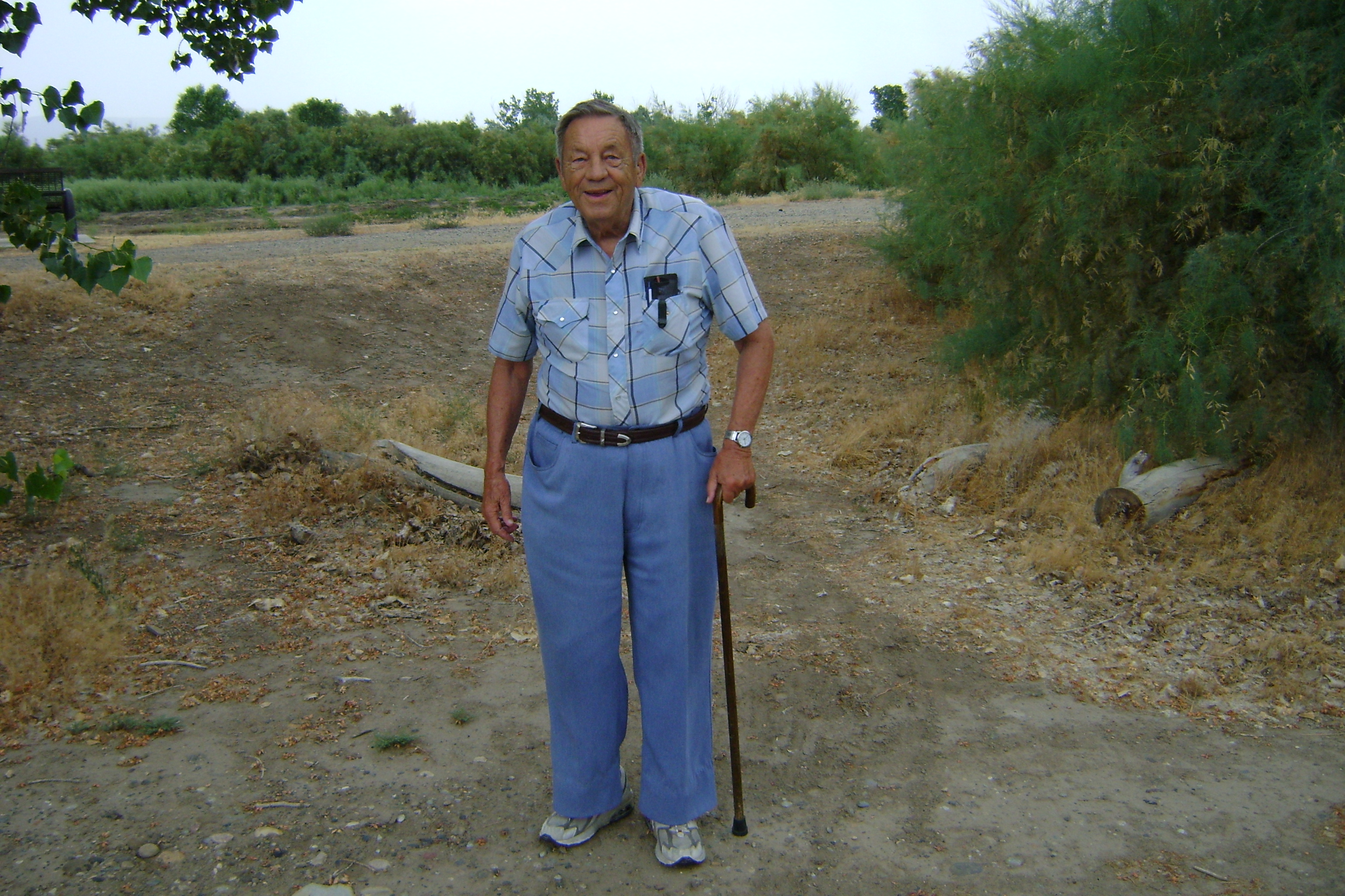
We just got back to Peru from a whirlwind trip back to the US. It was great, and exhausting. First, we had to take a 10-hour bus down to the coast from Cajamarca, then an 8-hour bus from Trujillo to the capital of Peru, Lima. Then we flew for ages to Boston, and we arrived in time for the main event that timed our trip: The 80th birthday celebration of Nancy's dad, Frank Lewis. We went to her brother Dan's cabin in New Hampshire and had a delightful celebration.
Then we flew to Denver and got to see Randy's kids, Elisheba and Mark, and drove to Grand Junction, Colorado to see Randy's parents. We got to walk with them and see their new home at the Atrium living center in Grand Junction - they have a beautiful cottage, complete with even more space than they had before, a garage, and a meal a day at the nice facility next door. Very good setup.
Then we drove back to Denver and had a get-together with friends which was an absolute delight. Several friends came to say hello, and even one set of bike tourists we'd never met, Nick and Dave, two impressive young men who are about to set off from Denver on their way to Panama. Thanks to all of you who came and who couldn't for your friendship! read more here... lee mas aquí... »
Lucho and the Casa de Ciclistas in Trujillo, Peru
When we came down from the mountains of Peru to the coast we stayed at the fabled Casa de Ciclistas (House of Cyclists) in Trujillo, Peru. Lucho Ramirez started offering his simple house to passing touring cyclists clear back in 1984, and is on the edge of crossing the one thousand mark. One thousand groups of cyclists have signed his journal and stayed there over almost 25 years! One cyclist stayed a year! Many stay far longer than they expect to, often for a week or more. It's a delight to browse through the journals and see famous cyclists that we've either met or heard of who passed this way. Our friends Dick and Els, from Holland, signed the book about 5 years ago. Our friend Andrew signed it just a month or so ago. Our friends Pat and Cat also passed through about 3 years ago.
Many of you have asked us if we're setting some kind of a record or something, and the answer is no, we're really slow, and lots and lots of people have gone farther. Although not all the cyclists who have stopped at Lucho's house were doing rides as big as ours, many were doing rides much bigger. One fellow, Hans Stuecke, has been cycling for 46 years!
Anyway, Lucho provides a tremendously friendly place for cyclists stop, recharge, get their equipment worked on, and generally have a wonderful memory. We left our bikes safely there for our trip home, and came back to find them waiting for us. read more here... lee mas aquí... »
Cyclists before us at the Casa de Ciclistas

People often ask us "Has anyone ever done this before?" or "Are you setting a new Guinness Record?". The answer, of course, is an authoritative NO! We know this, of course, but stopping at the Casa de Ciclistas in Trujillo and looking through the logs makes us really feel humble. We were the 998th entry over 24 years. Plenty of people have been through here! There are slow people and fast, many rides as long as ours, but many much longer. Here are a few links and a few details about some of the folks who have signed their names in the logs at Trujillo.
- Hans Stuecke
- Hans has been bike touring for 46 years, and has visited at least 193 countries. He really HAS set a Guinness record. I don't think we're going to touch his record anytime soon!
- Dominic Gill
- Dominic started his ride about the same time as we did, and we actually met him for a few moments in Whitehorse, Yukon Territory. But Dominic just finished riding a tandem (most of the time by himself, alone) with gear for himself and a guest, all the way from Alaska to Patagonia. His gear weight was incredible, but his idea was "Take a Seat". He invited anybody who wanted to to come along for a ride for as long as they wanted. He had incredible experiences.
Back on the road, Climbing up into the mountains
Click here for all of our favorite photos from this section
After more than three weeks of not riding we are back on the road once again in Peru. We made a two-week trip back to the United States to see all our family members and are glad to report all are well. It was good to see the family as well it was a delight to see all our wonderful friends.
We returned to Trujillo, Peru and stayed once again at the Casa de Ciclistas where Lucho and his family have offered free hospitality to cyclist for 23 years. Randy and I were visitor 998. While staying there, we meet 7 different cyclists from all over the world.
We have now been on the road for 5 days and are taking a rest day in Caraz. The ride from the coast up to Caraz has been amazing, spectacular, a hard ride on mostly dirt road, some good and some awful. The best part is the lack of traffic which permitted us to enjoy the majestic views of the mountains and the river valley we pedalled through.
We rode for one day on the Panamerican highway south to Chao. The road had a good shoulder, big trucks and a landscape which brought to mind the sand dunes of Saudi Arabia. Huge hills, not really mountains, of nothing but sand dunes. Nothing lived in this region, no houses, no people, no business thrived, no birds chirped, no butterfly fluttered by. read more here... lee mas aquí... »
Health, Healthcare, Health Insurance, and Vaccinations for the big ride
People often ask us about health-related issues, so here are some answers.
Health Insurance: Since we are from the US, with an immensely expensive and burdensome healthcare system, we felt that we had to carry health insurance that would cover us there. Although we might be able to cover expenses for most types of events in the other countries of our journey, a single week in a hospital in the US can easily bankrupt anyone. So we carry normal (expensive) major medical, high deductible ($10,000) health insurance that would cover us if we had to go limping home for a major chronic illness or something. But that insurance doesn't cover us outside the US, so if we had a serious accident or something, we could end up without coverage. So we also bought health insurance that covers us outside the US (cheaper by far). Our monthly expenses for health insurance are probably the biggest expense of the trip.
Note that "Trip insurance" is not worth much for a trip of this size, since it is not renewable and typically has pretty serious limitations. It's oriented to people going on vacation, not to people living abroad. What we needed (and most travellers will need) is the type of insurance that expatriates buy. The folks at Global Insurance Net make a specialty of this type of insurance, and we were pleased with their expertise and service.
Health Care: We've been pretty pleased with healthcare everywhere we've been. read more here... lee mas aquí... »
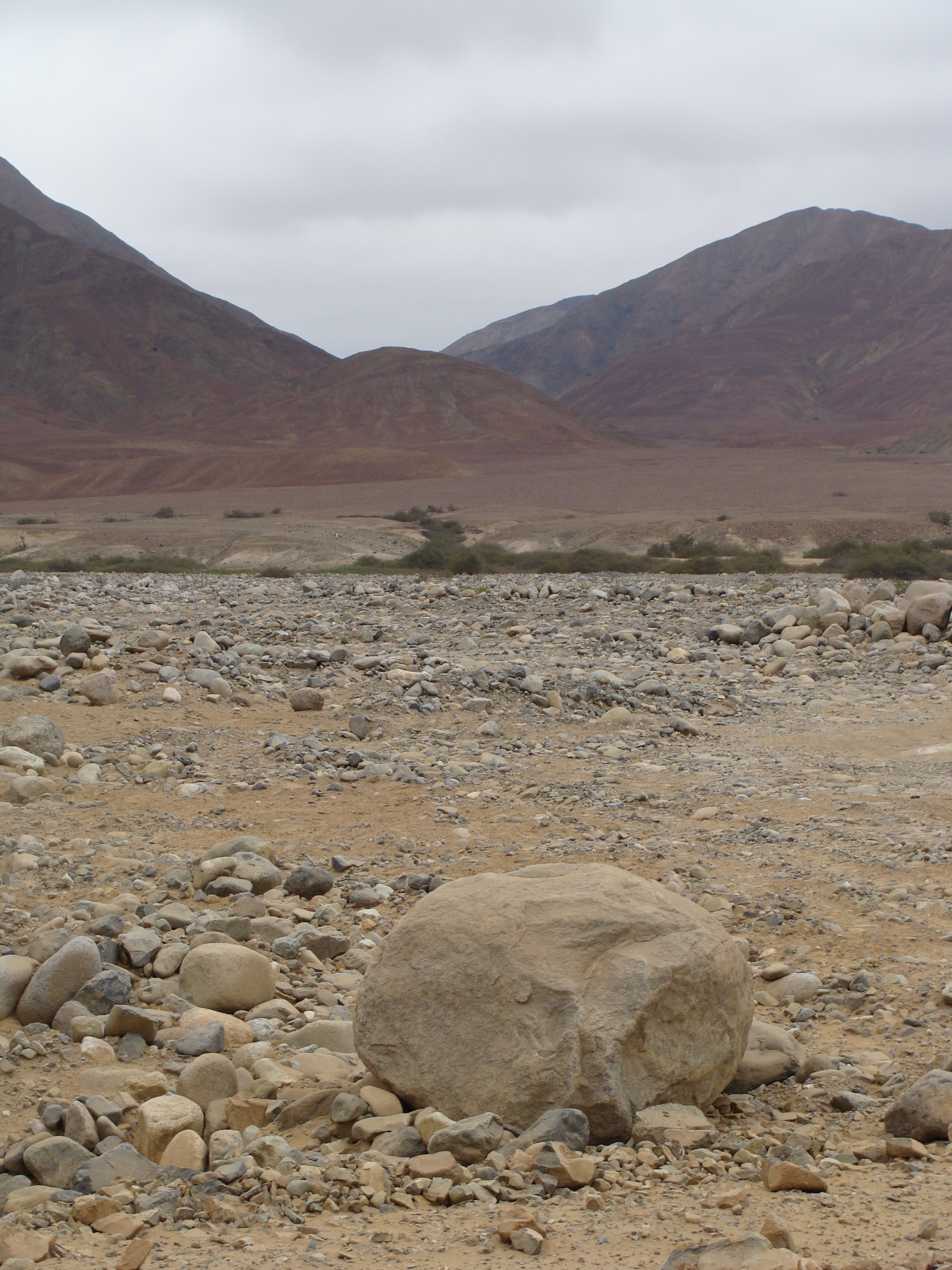
Our highest point yet: 15,400 feet (4700 meters)

Today we crossed the highest point of our journey so far, and perhaps the highest of the trip. After climbing back up into the Andes (the Cordillera Blanca) for more than a week, we crossed over 15,400 foot (4700 meter) Abra Yana Shalla. We had been working our way up to this, climbing no more than 1000 meters per day as we got into the really high places. Nancy really felt the altitude in a number of ways, so we were trying to be as careful as possible. But we made the last push this morning up into the barren peaks. We saw lots of beautiful scenery in the last few days and will try to get the pictures uploaded within a few days.