Blogs
Whitehorse, Yukon. Tomorrow we get to Inuvik!
We flew from mile 0 of the Alaska Highway all the way to Whitehorse, Yukon Territory. It's 10:11pm and the sun won't go down for more than an hour. But tomorrow the sun won't go down at all.
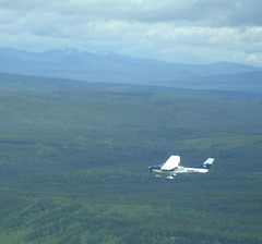
The flight was wonderful today - we hugged the river due to low-hanging clouds and had great views of beautiful places. The ride over the Continental Divide was spectacular.
Hope to update you more and provide some pictures from Inuvik, if we have internet access.
Dawson Creek, BC
Today our airlift of 12 planes flew us about 800 miles today from Helena, Montana up to Dawson Creek, BC, Canada, the beginning of the Alaska Highway. Some of it was a bit choppy, but it was a successful trip.
You ask why we need 12 planes to get us to the North Country? We have no idea. When we were planning this trip, my brother Collin and sister-in-law Marisa asked if we wanted a ride up there in their Centurion light plane. We said yes. They also invited many, many of their Parkwest Air Tours clients... and all of them said YES! So it's a really big group.
Tomorrow we go on to Whitehorse, Yukon Territory if the weather works, or perhaps to Dawson City, at the bottom of the Dempster.
As I write this, the temperature in Inuvik is 2 degrees above freezing, and we're wondering if we're really ready for that kind of temperatures. The forecast is a little better than that, though, and cooler temps mean less mosquitoes...
We are in Grand Junction where we will fly out of
Today is June 1st, 2006 and we are really doing it, we on our way. After months of prep we are on the road but not on our bikes. We drove to Grand Junction where we will fly out of Grand Junction Airport (Walker Field) in the morning in a Cessnar piloted by Collin Fay and Marisa Fay. Collin and Marisa do this all the time with their business, Parkest Air Tours.
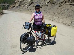
We are flying to Helena, Montana to meet 13 other small planes which will fly us to Inuvik and drop us off with our bikes and all the gear. We will then ride south on the Dempster Highway, a 450-mile gravel road with very limited services. What a great way to see the world.
Wish us luck and good riding weather.
Dempster Highway Ferry Crossings
We're starting as early in the year as would be possible. In April, the Dempster is closed when the rivers start to melt, taking out the ice bridges. The highway reopens in June when ferries can operate.
The current road report shows that the ferries are not yet running on the Dempster as of May 23. If we started today, we could not ride the highway.
The historical data for the Peel River Crossing and the Mackenzie River Crossing show that the ferry usually starts running the first week of June, but in 1977, it didn't start until June 16. I don't know why we chose June 9 as a starting date because we didn't know anything about this. But I'm glad it looks like it was a reasonable date!
The Far-North Weather Page

Here are readings for Rock River, which was about 200 miles into the journey.
Gear Page is up!
Platypus Water Bladders
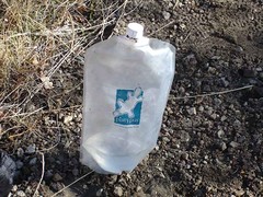
We've also ordered a new item from Ortlieb: A 10-liter water bag (with shower fitting!). We'll use it for unfiltered water. It can be used to haul water before it's filtered with our Pur.
(Katadin) Hiker water filter.
MSR Whisperlite Stove
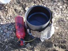
We use denatured ethyl alcohol to prime it - and never have to clean it any more. It's so much more reliable. See the article here.