Road down to batopilas
By nancy - Posted on March 21st, 2007
Tagged: Inuvik to Ushuaia
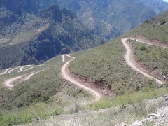
The ribbon road down to Batopolis is one of the most amazing road engineering projects. The road twists its way down 5000 feet (1800 meters) through 5 ecosystems and millions of years of rock formations.
If you look very closely at this photo you may see the foot paths and used by the Tarahumara (Raramuri) Indians to access the resources of this canyon and the way the people of this region travel to and from the outback.
We hitched a ride down to the bottom with four Canadians driving this dusty, teeth rattling, back jarring road. It took around 5 hours to drive this 65k (40 mile) road. Around every corner was a new photo opportunity. We also hitched back with a kind couple from Mexico City who had hired a guide to bring them down and back up to creel.
(Thank you folks for the ride and the time we had to share).
The road was only really wide enough for one car so if another vehicle came around the corner, one of the drivers had to back up or down the road to a spot wide enough for both to squeeze by.