Blogs
Zacatecas band winding through the streets
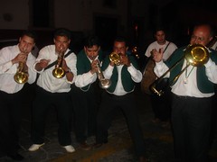
In Zacatecas there is a tradition (I think especially on Saturday nights) of bands winding their way through the streets - kind of a roving party. People follow them around and drink mezcal. We heard one on Saturday night and followed it all over the city - it seemed like we went though every little alley. They were amazing entertainers. They always had something new going. The funniest thing was when we were going through a narrow alley and a dog was barking at us from a balcony above. The whole party stopped, and the band started a piece that involved barking. Every so often they'd stop and we (the whole crowd) would bark back at the dog!
Update: New Pictures and a Podcast (Audio)
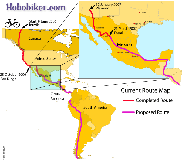
- Our location: We're in Parral, about 200 miles south of Chihuahua, having exited the southeast end of the Copper Canyon region. Nancy did up a wonderful new map of our route (below) so you can see our route.
- New pictures: There are a lot of new pictures on the photos page.
- Podcast: We have started an experimental podcast (audio listen) for you. Click the Podcast button on the top of the page.
Randy at breakfast
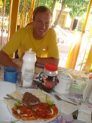
We have decided this dish is an excellent meal to power us on our bike ride. (Protein, Fat, and carbohydrates). Tamales are another food we have discovered is an excellent biking food.
Road down to batopilas
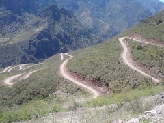
If you look very closely at this photo you may see the foot paths and used by the Tarahumara (Raramuri) Indians to access the resources of this canyon and the way the people of this region travel to and from the outback.
We hitched a ride down to the bottom with four Canadians driving this dusty, teeth rattling, back jarring road. It took around 5 hours to drive this 65k (40 mile) road. Around every corner was a new photo opportunity. We also hitched back with a kind couple from Mexico City who had hired a guide to bring them down and back up to creel.
(Thank you folks for the ride and the time we had to share).
The road was only really wide enough for one car so if another vehicle came around the corner, one of the drivers had to back up or down the road to a spot wide enough for both to squeeze by.
Batopilas aquaduct
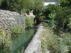
Along the way she swam in the Rio Batopilas river, panned for silver, meet a goat herder, and also a guide on a horse returning from a 3 day trip to Urique and back to Batopolis. Most stunning were the flowering cactus and trees found in this deep desert canyon.
View La Bufa in the bottom of Copper Canyon, Mexico
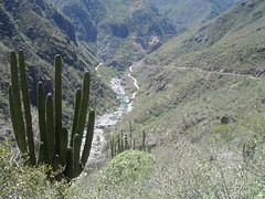
Here is a photo overlooking the road to La Bufa and eventually to Batopilas.
This area is the home to the famous Indians Traumara (Raramuri). One of the oldest people in North America, migrated to this area to avoid conflict with the Spanish Missionary. This shy group of people who live a subsistence life style can be recognized by their unique clothing and dark skin. The men wear a white loincloth, sandals, and an array of shirts and the women wear colorful layered blouses and skirts and large scarfs of multi designs.
It does appear the Traumara (Raramuri) have huge struggles with health, farming in this harsh climate though they have some of the most efficient farming methods known, and preservation of a culture that is in conflict with a monetary society.
The death rate for women giving birth is one in ten. The death rate amoungst children under 5 is 50 percent. Poverty amongst these people in this area is so rampant it touches everyone. read more here... lee mas aquí... »
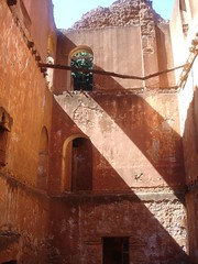
Exhacienda Minera near Batopilas
Even today there are mining activities in the far mountains in Copper Canyon where new roads have been built giving people access to areas of this region where before only foot access was possible.