Route Reports
Bike Touring The Dempster Highway - Our Report
- Resources
- The Milepost is essential. Copy or rip out the section about the Dempster and you'll know where every pullout and campground is.
- Alys and Pete's book Alaska Bicycle Touring Guide is getting mighty old, but it's the only place you can find out where water is available. That's something that matters to a cyclist and not to most other travelers.
- Journals from other riders who did the Dempster: Jeff Kruys (2006), Murray Snyder (2006), Mike Vermuelen (1996)
- Things you'll need
- Mosquito headnet (or full body suit) and repellent. Mostly we liked the headnet instead of repellent.
- Bear Cache/Cannister (or see our note on using garbage cans as a cache)
- Eye protection - lots of dust and things flying.
Touring Cyclists' Report on the Cassiar Highway

- The Cassiar is a cyclist's delight, even though we had a fairly rough time with it. The traffic is light, the road is generally good, and the services are more frequent than we expected.
- The road is mostly paved (about 90%) and not too difficult. There are plenty of hills, but no huge passes. The 10% that is not paved can be fairly difficult (it was all mud for us, and we hate mud). But it's not really all that bad. They expect to finish all the paving in the next couple of years.
- We found groceries at several places we didn't necessarily expect them. The stores at Good Hope Lake, Dease Lake, Iskut, and Stewart all had groceries. All of those except Good Hope Lake had excellent variety. However, there was nothing at Meziadin Junction. The kind woman at Moose Meadows (north of Dease River Crossing, which is north of Dease Lake) also stocks some imperishables just for the cyclists who come through.
- Go to Stewart and Hyder. You'll regret passing them by, even though they're off the route. You'll want to see the glaciers and the bears at Fish Creek!
Vancouver Island touring cyclist report

Vancouver Island is about 300 miles long on the highway. We had a pleasant time touring it, but were surprised by the traffic on the narrow road up north (no surprise since we've been on the easy northern roads for so long).
The section from Port Hardy to Port McNeil was quite pleasant, and we really liked Alert Bay, and also went to Sointula. Very nice cycling.
From Port McNeil to Campbell River was quite bad - much of it has no shoulder, and there are lots of big trucks, including logging trucks.
From Campbell River to Nanaimo was rideable, but not terribly pleasant. There was a lot of traffic on a road with adequate shoulder, but certainly too much traffic.
From Nanaimo south, the roads were great, like New England. Small country roads with little traffic and nice views (and nice hills). Very pleasant. Lots of access to the various islands. We used a bicycle-specific map for this area, the "Victoria/Gulf Islands Cycling and Walking Map". It gave lots of information about the various routes and got us off the main highway.
And the Victoria area (especially Sidney) is delightful, with lots of access to everything for cyclists.
Pacific Coast Route Touring Cyclist Report

The US Pacific Coast is one of the most popular tours in the world. Despite our plans, we ended up doing the whole thing (just under 2000 miles), and I wanted to write a few notes about this incredibly beautiful trip and the wonderful resources that are provided for touring cyclists.
You just can't believe how well-set-up the Pacific Coast is for the touring cyclist. There are books on how to do it, there are wonderful state parks all the way with hiker-biker sites at ridiculously cheap prices and with a shower every night. You never have to buy food ahead of time or plan your food carefully or carry any - there's another town with a nice grocery where you can buy it.
One other unique characteristic: It's so nicely set up for touring cyclists that there are an enormous number of them. And since everybody is in the hiker-biker sites, you get to meet all the touring cyclists. Whereas in the north country we might meet the occasional cyclist, and might end up camping with them, on the coast it's every night you're meeting a bunch of people. It was so intense that there was a night in California that I hid in my tent because I just couldn't seek out the stories of all those people and tell them our story. There were too many. read more here... lee mas aquí... »
Peru Route: July 13 to October 9, 2008
Here is our route in Peru.
Each day has elevation profile, map, and GPS information.
Other recommended information sources::
- We used the trip notes from 2bike.be,(at the bottom of the page) which are quite detailed and very useful. They include total elevation and what shops and hospedajes are found along the way.
- PDFs of daily route notes from Florian and Rebekkah are gems of information. These are rehashes of a set that has been carried by many cyclists.
- Also, Pius and Stefan of panamerica.ch have done a great job with more consolidated elevation profiles than we show here. Take a look at their Peru map page and study their route profiles in PDF format. They took our same route from Trujillo to Bolivia.
- Maps: We used the Rough Guide Map of Peru most of the time, and thought it was pretty decent. ITMB also has a map, and Lima2000 has a pretty decent map that you can get within the country.
- GPS: The free routeable GPS maps at perut.org have been recommended highly. Also, Guiacalles.com in Lima has a full GPS map for sale.
Skip to:
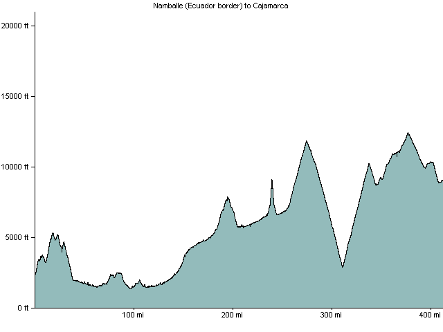
Ecuador border to Cajamarca
The route we took is difficult and opened only in 2000 or so, so most cycle tourists seem to go the Panamerican Highway from Loja, Ecuador to Trujillo, Peru. This is fairly fast, but they all hate it. On the contrary, we really loved the mountainous way we went, even though it's challenging.
From the border there is a gentle but long climb of 1300 meters and then a descent into San Ignacio. It's mostly downhill then to the valley of the Rio Marañon at just 400 meters of elevation. We took a turnoff and went through Bella Vista instead of staying on the main road through Jaen. This saved many kilometers and was a pretty pleasant (dirt) road cutoff. We took a small ferry across the river just beyond Bella Vista.
After returning to the highway and getting to Bagua Grande, we started the beautiful climb up the Rio Utcubamba to Pedro Ruiz. Because of road construction we had to take a combi from the intersection there to Chachapoyas. Then lovely dirt road to El Tingo (Kuelap) and Leymebamba. From Leymebamba to Celendín is a huge climb and drop to the Rio Marañon again; we did it in a potato truck. Then from Celendín to Cajamarca is one pass - there is pavement on the Cajamarca side. We took a bus from Cajamarca to Trujillo.
| Ride | date | miles/km | Elev ft/mt |
|---|---|---|---|
| Namballe, Peru to San Ignacio, Peru | 2008-07-13 | 28/45 | 4300/1327 |
| San Ignacio to Tamborada | 2008-07-16 | 45/73 | 1650/509 |
| Tamborada to Bagua Grande via Bella Vista | 2008-07-17 | 43/69 | 2034/628 |
| Bagua Grande to Pedro Ruiz and by combi to Chachapoyas | 2008-07-18 | 42/68 | 3600/1111 |
| Chachapoyas to El Tingo | 2008-07-19 | 23/37 | 518/160 |
| El Tingo to Kuélap by car | 2008-07-20 | 1/2 | 4000/1235 |
| El Tingo to Leymebamba via Revash | 2008-07-21 | 35/56 | 2332/720 |
| Leymebamba to Celendín by potato truck | 2008-07-22 | 89/144 | /0 |
| Celendín to Cruz Conga | 2008-07-23 | 21/34 | 2539/784 |
| Cruz Conga to Cajamarca, Peru | 2008-07-24 | 47/76 | 2122/655 |
Trujillo to Huancayo
The route from Trujillo to Huancayo is pretty standard (and fairly difficult) for bike tourists. You ride a little ways south on the Pan American Highway to 15km south of Chao, then turn into a private road, climb up to the Cañon del Pato, up to Huaraz, then either through the national park or around the paved road and over a 4700 meter pass, then through several ups and downs until Huánuco. From Huanuco it's pavement up and over Cerro de Pasco then to Huancayo. There´s an excellent elevation profile on panamerica.ch showing this stretch.| Ride | date | miles/km | Elev ft/mt |
|---|---|---|---|
| Cajamarca to Trujillo (by bus) | 2008-07-26 | 1/2 | /0 |
| Trujillo to Chao, Peru | 2008-08-16 | 42/68 | 1456/449 |
| Chao to Chuquicara | 2008-08-17 | 46/74 | 2500/772 |
| Chuquicara to Camp 8km before Yuracmarca | 2008-08-18 | 30/48 | 2063/637 |
| Camp near Yuracmarca to Huallanca, Peru | 2008-08-19 | 13/21 | 1794/554 |
| Huallanca to Caraz, Peru | 2008-08-20 | 25/40 | 2700/833 |
| Caraz to Huaraz, Peru | 2008-08-22 | 43/69 | 3600/1111 |
| Huaraz to Cátac, Peru | 2008-08-24 | 23/37 | 1800/556 |
| Catac to Conococha | 2008-08-25 | 29/47 | 2237/690 |
| Conococha to Pachapaqui | 2008-08-26 | 25/40 | 1978/610 |
| Pachapaqui to Huallanca, Huánuco, Peru | 2008-08-27 | 30/48 | 2405/742 |
| Huallanca (Huánuco) to La Unión | 2008-08-28 | 13/21 | 190/59 |
| La Unión to Tingo Chico | 2008-08-30 | 20/32 | 1204/372 |
| Tingo Chico to Chavinillo | 2008-08-31 | 23/37 | 2270/701 |
| Chavinillo to Huánuco, Peru | 2008-09-01 | 45/73 | 1787/552 |
| Huánuco to Huariaca | 2008-09-04 | 43/69 | 3667/1132 |
| Huariaca to Huancayo by car and bus | 2008-09-05 | 1/2 | /0 |
Huancayo to Lake Titicaca and the Bolivian Border
From Huancayo we took the dirt road through the canyon (Rio Mantaro) for 5 days to Ayacucho. Many people take the partly paved route over a high pass to Huancavelica instead. From Ayacucho we took a bus to Cusco - the dirt road from Ayacucho to Abancay is very difficult, and we were tired. From Cuzco there's just one pass and it's easy, then mostly things are flat to the Bolivian border. All paved, sometimes smooth and sometimes not.Take a look at the excellent elevation profiles for this section on panamerica.ch (only to cusco).
| Ride | date | miles/km | Elev ft/mt |
|---|---|---|---|
| Huancayo to Mariscal Cáceres | 2008-09-13 | 49/79 | 2700/833 |
| Mariscal Cáceres to Camp before Anco | 2008-09-14 | 41/66 | 2083/643 |
| Camp near Anco to Mayocc | 2008-09-15 | 27/44 | 1456/449 |
| Mayocc to Huanta, Peru | 2008-09-16 | 20/32 | 2047/632 |
| Huanta to Ayacucho, Peru | 2008-09-17 | 30/48 | 2381/735 |
| Ayacucho to Andahualas by bus | 2008-09-21 | 1/2 | /0 |
| Andahuaylas to Cuzco by bus | 2008-09-22 | 1/2 | /0 |
| Cuzco to Quiquijana | 2008-09-29 | 44/71 | 485/150 |
| Quiquijana to Sicuani | 2008-09-30 | 44/71 | 1824/563 |
| Sicuani to Santa Rosa | 2008-10-01 | 42/68 | 2677/826 |
| Santa Rosa to Calapuja | 2008-10-02 | 71/115 | 593/183 |
| Calapuja to Puno, Peru | 2008-10-03 | 44/71 | 869/268 |
| Puno to Ilave | 2008-10-07 | 35/56 | 1410/435 |
| Ilave to Yunguyo | 2008-10-08 | 49/79 | 2033/627 |
| Yunguyo, Peru to Copacabana, Bolivia | 2008-10-09 | 7/11 | 528/163 |